What it is
A small coral island off the coast of Nampula province, joined to the mainland by a long single-lane bridge, carrying a dense stone town at one end and a reed-built town at the other. It was the capital of Portuguese East Africa for close to four centuries, and it gave the country its name.
UNESCO inscribed it in 1991 under criteria (iv) and (vi). The inscribed property covers 95.7 ha with a buffer zone of 6,026.02 ha, and it is recorded as a serial property.
What UNESCO actually recognized
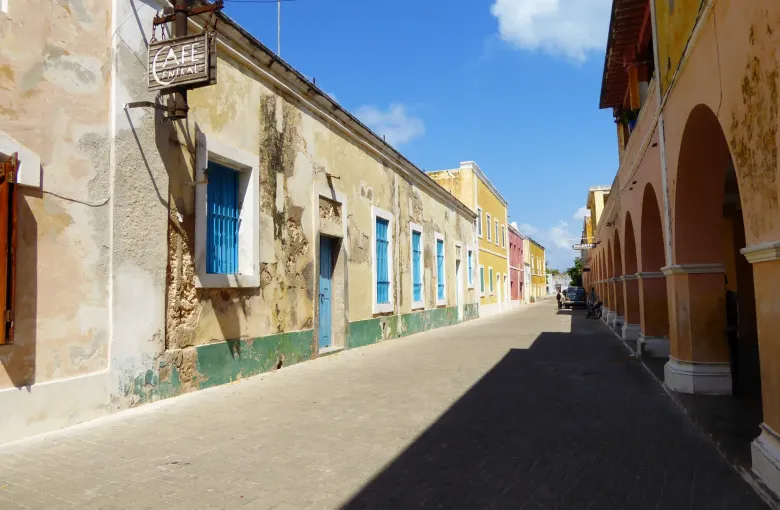
Not one building, and not the Portuguese period alone. The value is in the meeting of cultures visible in the fabric of the town: Swahili, Arab, Indian and European building traditions worked into the same few streets over centuries of Indian Ocean trade.
That is why the island reads the way it does. Lime-washed facades with deep verandas stand beside mosques and Hindu temples; the same street carries a Portuguese church and a Swahili courtyard house. The Fortress of São Sebastião holds the northern end, and the Chapel of Nossa Senhora do Baluarte inside its walls is among the oldest European buildings in the southern hemisphere.
UNESCO's own record notes the island's continuing conservation challenges: this is a living town of several thousand people, not a preserved ruin, and the international assistance record for the property includes a rehabilitation project for the São Sebastião fortress.
The advisory detail that matters
The island is in Nampula province, and Nampula appears in both travel advisories. Read the districts rather than the province.
The FCDO advises against all travel to the districts of Memba and Eráti in Nampula, and the US names certain districts in the north of Nampula as Do Not Travel. The Island of Mozambique is in neither. It sits in its own district on the coast, well south of the restricted ones.
That distinction is the whole point of reading an advisory properly. A province named in a warning is not a province closed, and the districts are named precisely so that a traveler can tell the difference. Check both advisories yourself before you travel, because the boundaries of the restricted areas have moved before.
Getting there
The usual route is a domestic flight to Nampula city and then a road transfer to the bridge, which takes several hours. The bridge is single lane with passing control, so arrivals come in waves.
Once on the island, everything is walkable. That is the pleasure of it: this is a place to spend two or three days on foot rather than to see in an afternoon.
Visiting well
- Take a guide from the island. The town is layered and much of what matters is not labeled. A local guide is the difference between a pretty street and a legible one.
- Dress modestly. This is a working town with a strong Muslim presence, not a resort. Shoulders and knees covered.
- Ask before photographing people, homes or worship. Several thousand people live here and they did not consent to be scenery.
- Walk the whole island. Stone Town at the north and Makuti Town at the south are both part of what was inscribed, and seeing only the first gives a false picture of the place.
- Carry cash. See the money guide.
When to go
The dry season, roughly May to October. Walking a stone town in full wet-season humidity is hard work, and the sea crossing and road transfer are both easier. See our best time to visit guide.
Health, because it applies here too
Malaria is present across Mozambique including the north, and the CDC recommends prescription medicine to prevent it for travel anywhere in the country. Evening cover and repellent matter on the island as much as anywhere. Note also that the FCDO reports a cholera outbreak in central and northern areas, so the usual water precautions apply.
Sources
- UNESCO World Heritage Centre: the inscription of the Island of Mozambique in 1991 under criteria (iv) and (vi). Accessed 14 September 2026.
- UNESCO World Heritage Centre: Mozambique’s State Party record, which lists two properties inscribed on the World Heritage List. Accessed 14 September 2026.
- UK Foreign, Commonwealth & Development Office: Mozambique travel advice and the areas it advises against traveling to. Accessed 14 September 2026.
- UK Foreign, Commonwealth & Development Office: Mozambique regional risks, province by province. Accessed 14 September 2026.
- US Department of State: the Mozambique travel advisory, currently Level 2, Exercise Increased Caution, with Do Not Travel areas in the north. Accessed 14 September 2026.
Other Articles
Maputo National Park: Visitor and Heritage Guide
Best Time to Visit Mozambique