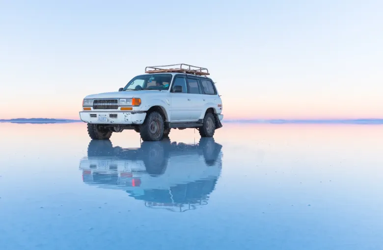
Ten thousand square kilometers of salt sit on the Bolivian altiplano at around 3,650 meters, flat to within a meter or so across the whole of it. The Salar de Uyuni is the largest salt flat in the world, it is the single image most people carry of this country, and standing on it is one of the few landscapes that genuinely resists being photographed well.
⚠ It is not a World Heritage Site
This surprises almost everyone, so it is worth being direct about it. The Salar de Uyuni is not inscribed on the World Heritage List. It appears on Bolivia's Tentative List, which is the register of sites a country has indicated it may nominate in future, and which confers no inscription and no status.
Bolivia does have inscribed properties, and they are elsewhere: the city of Potosi, the Jesuit Missions of the Chiquitos, the historic city of Sucre, the Fuerte de Samaipata and Tiwanaku. You may have read otherwise. That is a common error rather than a fact, and it is not repeated here.
None of which makes it less worth going to. It simply is not the thing people think it is on paper.
The two Salars, and you must choose
The flat is a completely different place depending on the season, and no itinerary gets both.
The dry season, roughly May to October. The surface is hard white salt, cracked into the polygon pattern that forms as brine evaporates, and vehicles cross it freely. This is when Isla Incahuasi, the rocky island covered in giant cacti out in the middle of the flat, is reachable, and when the perspective photographs that people come for are possible. Nights are severely cold.
The wet season, roughly November to March. A shallow film of water lies over part of the flat and turns it into a mirror that reflects the sky end to end. It is the more extraordinary of the two and the more restricted: operators route around deeper water, parts of the flat become unreachable, and the island may be cut off entirely.
Getting there and going out onto it
Trips start from the town of Uyuni, which is reached by road or by overnight bus from La Paz, Oruro, Potosi or Sucre, and by air from La Paz to the small airport outside town. Tours run as single days, or as the classic three day circuit that carries on south through the colored lagoons, the Sol de Manana geysers and the Eduardo Avaroa reserve toward the Chilean border.
Choosing an operator is the decision that matters most. The three day route crosses remote country at high altitude with limited communications, and vehicle condition, driver experience and whether there is a second vehicle in convoy are the things worth asking about. Ask too where you will sleep: the salt hotels and the basic refuges on the southern circuit are a different proposition from a hotel in Uyuni.
What it is like
- It is cold. The flat sits above 3,600 meters and the southern circuit goes higher still, past 4,800 meters. Nights on the three day route are the coldest most visitors will have experienced. The packing list takes this seriously.
- The light is punishing. Sun reflecting off white salt comes at you from below as well as above. Sunglasses and high factor sun protection are not optional, and you will burn under your chin if you skip it.
- There is no shade and no shelter. Carry water, and carry more than you think.
- Altitude applies here as everywhere on the plateau. Do not make the Salar the first thing you do after flying into La Paz; see the travel safety guide.
The train cemetery, and what it is
Just outside Uyuni sits a field of rusting nineteenth and twentieth century locomotives, left where the mineral railways that once ran from here finally stopped. Almost every tour stops there. It is genuinely striking, and it is also a piece of the same industrial story that built Potosi: these were the lines that carried ore out. The Potosi guide takes up the other end of it.
Sources
- UNESCO World Heritage Centre: Bolivia States Party record: the properties Bolivia has inscribed on the World Heritage List, and separately the Tentative List of sites it may nominate in future. Accessed 17 September 2026.
- UK Foreign, Commonwealth and Development Office: Bolivia travel advice: the index to the entry, safety, regional and health pages this cluster draws on, the advice against all but essential travel to the Chapare region of Cochabamba Department, the State of Emergency under which police and armed forces may detain a person who does not comply for up to eight hours without charge, and the standing guidance that no travel can be guaranteed safe. Accessed 17 September 2026.
- Centers for Disease Control and Prevention: Bolivia traveler health: a yellow fever vaccination certificate required for all arriving travelers aged one year and over, and separately a vaccine recommendation limited to travelers aged nine months and over going to areas below 2,300 meters east of the Andes, namely the entire departments of Beni, Pando and Santa Cruz and designated areas of Chuquisaca, Cochabamba, La Paz and Tarija, with the vaccine not recommended above 2,300 meters; malaria risk recorded in areas below 2,500 meters and none recorded in the city of La Paz. Accessed 17 September 2026.
Other Articles
Best Time to Visit Bolivia
What to Pack for Bolivia