The first thing to unlearn about Colombia is the calendar. The country straddles the equator, so there is no summer and no winter in the sense most visitors mean. Day length barely changes across the year, and temperature is decided almost entirely by altitude rather than by month. What does change is the rain.
The two dry periods, and what they are worth
Most of the Andean interior runs on a broadly bimodal pattern: a drier stretch around December through March and a shorter one around July and August, with wetter periods between them. That is the shape behind most Colombian travel advice, and it is reliable enough to plan by and not reliable enough to promise.
Two qualifications worth carrying. Rain in the Andes usually means a heavy afternoon rather than a lost day. And the driest months are also the busiest and the most expensive, because they coincide with Colombian school holidays and the New Year.
Region by region
Bogota and the high Andes. Cool and changeable all year. December through March is the drier stretch and the clearest. Bring layers in every month; the difference between sun and shade at that altitude is larger than the forecast suggests.
The coffee region. Green because it rains, and the rain is why the landscape looks the way it does. December through February and July through August are the drier windows. The coffee cultural landscape is worth seeing in either.
Cartagena and the Caribbean coast. Hot and humid all year. December through April is the drier and breezier half; the wettest stretch runs roughly September through November. Christmas and New Year on the coast is spectacular and fully booked.
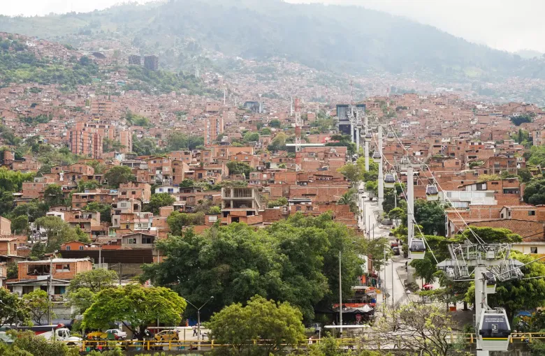
Medellin. The city advertises itself as the city of eternal spring and the claim is broadly fair: comfortable all year, with wetter spells around April and May and again around September to November.
The Pacific coast. Wet is the default condition here, not the exception. The reason to come is the humpback whales, which are present roughly July through October. Note that most of Choco is on the restricted list in the cited advisory, with Nuqui, Bahia Solano and Quibdo named as exceptions, so this is a region to plan around the advisory rather than around the weather. The safety guide sets that out.
The Amazon and the eastern plains. Wet all year with a wetter half. The rivers are high around March through June, which changes what is reachable by boat rather than whether you can go.
Timing a trip around a festival
Colombia's calendar is unusually full and several events are worth building an itinerary around rather than fitting in. The Carnaval de Barranquilla falls in the days before Lent; the Feria de las Flores and its Desfile de Silleteros fall in Medellin in August; Holy Week is observed seriously across the country and Popayan's observance is the best known. All of them move or cluster with the church calendar, so confirm dates for your year rather than trusting a guidebook. The festivals guide covers them.
The flip side is worth knowing too. During Colombian public holidays and the long weekends known as puentes, domestic flights, buses and coastal hotels fill and prices rise.
What actually decides your dates
For most itineraries the honest answer is that any month works and the differences are marginal. Two things matter more than the weather:
- Altitude. A trip that pairs Bogota with the Caribbean crosses thousands of meters in an hour's flight, and the weather guide explains what that does to you and what to pack for it.
- The region list. Some parts of the country carry an advisory whatever the month, and that shapes an itinerary far more than rainfall does.
Sources
- UK Foreign, Commonwealth & Development Office: Colombia health: the emergency ambulance number 123, the eight week lead time for vaccine advice, altitude sickness as a risk in parts of Colombia including Bogota and areas of Cundinamarca, Boyaca, Narino and Antioquia, tap water as safe to drink only in Bogota, and private facilities as good while public ones and those in smaller cities are generally ill equipped. Accessed 17 September 2026.
- UNESCO World Heritage Centre: Coffee Cultural Landscape of Colombia, inscribed 2011 under criteria (v) and (vi), a serial property of 141,120 hectares with a buffer zone of 207,000 hectares, comprising six farming landscapes and eighteen urban centers on the foothills of the western and central ranges of the Andes. Accessed 17 September 2026.
- UK Foreign, Commonwealth & Development Office: Colombia regional risks: the list of regions the FCDO advises against all but essential travel to, including Choco outside Quibdo, Nuqui, Bahia Solano and Capurgana, western Valle del Cauca including Buenaventura, the municipality of Jamundi, western Cauca, the South Pacific, Sanquianga and Telembi regions of Narino, southern Cordoba, the Uraba and Bajo Cauca regions of Antioquia, southern Bolivar, the Catatumbo region of Norte de Santander, Arauca outside its capital, and within five kilometers of the Venezuelan border outside Cucuta. Accessed 17 September 2026.
Other Articles
Colombia Weather Guide
The Port, Fortresses and Monuments of Cartagena